
Temples of Tibet
Temples of Tibet is a long-term research initiative that aims to visualize and analyze the profound changes to Tibet's monastic heritage over the last 70 years, following the occupation of Tibet and the Cultural Revolution. Our database currently displays the correct and precise geographic coordinates for over 2600 monasteries in Tibet, which is also reflected in the interactive map developed for our project Tibet from Above, where we continue to contextualize the significant of this data collection.
These findings draw from historical satellite images, archival text and photography, oral history, fieldwork, and past data generously contributed by our project collaborators. The case studies presented here are a 3D digital reconstruction of Nartang Monastery, with a methodology that combines shadow analysis, satellite image orthorectification, and architectural rendering with extensive historical research drawn from Tibetan, Chinese and Western visual and textual sources. Our 3D reconstruction of Nangchen Palace uses similar tools to develop a historically accurate model of the space.
We are grateful for continued collaboration with an interdisciplinary team of scholars and institutions: Dr. Karl Ryavec (University of California, Merced), Professor Gray Tuttle (Columbia University), Tsering Wangyal Shawa (Princeton University), the Treasury of Lives, and the Buddhist Digital Resource Center (BDRC). We hope this work informs future collaboration across fields to support cultural heritage preservation, especially in contexts where significant built manifestations of culture are lost.
This interactive map locates temples across the Tibetan Plateau with verified geographical points. More information can be found by hovering over each point. These are all sites of potential further investigation, as explored in our related project, Tibet from Above.
Nartang Monastery Digital Reconstruction
Throughout the early 10th to mid-20th centuries, Nartang Monastery served as a center for Tibetan Buddhist practice, a home for up to thousands of monks at a time, an educational campus, and a renowned printing press for sacred spiritual texts. The monastery is located in central Tibet, near the city of Shigatse. Though Nartang Monastery’s historical legacy as a key site of cultural and religious production endures, its original physical traces have been reduced to scattered outlines of its structural foundations. By 1967, the Cultural Revolution led to the complete destruction of Nartang, and today, its earthy footprints have been replaced by few new structures.
A review of studies, historical accounts, travelogues, and guidebooks reveal numerous inconsistencies between Nartang Monastery’s architecture as it existing today and as it did in the past. Acquiring details about Nartang’s historical structures and architecture require searching through sources in numerous languages, formats, and periods to piece together what are often only brief mentions of the Monastery.
The first reconstruction is a depiction of building masses on Nartang Monastery’s campus based on shadow analysis. The second reconstruction is a 3D model with detailed renderings of some of the Monastery’s most notable spaces. The visual depiction has been substantiated by in-depth historical research into the design of Nartang’s buildings and campus plan. Architectural rendering and historical research informed each other throughout the project.
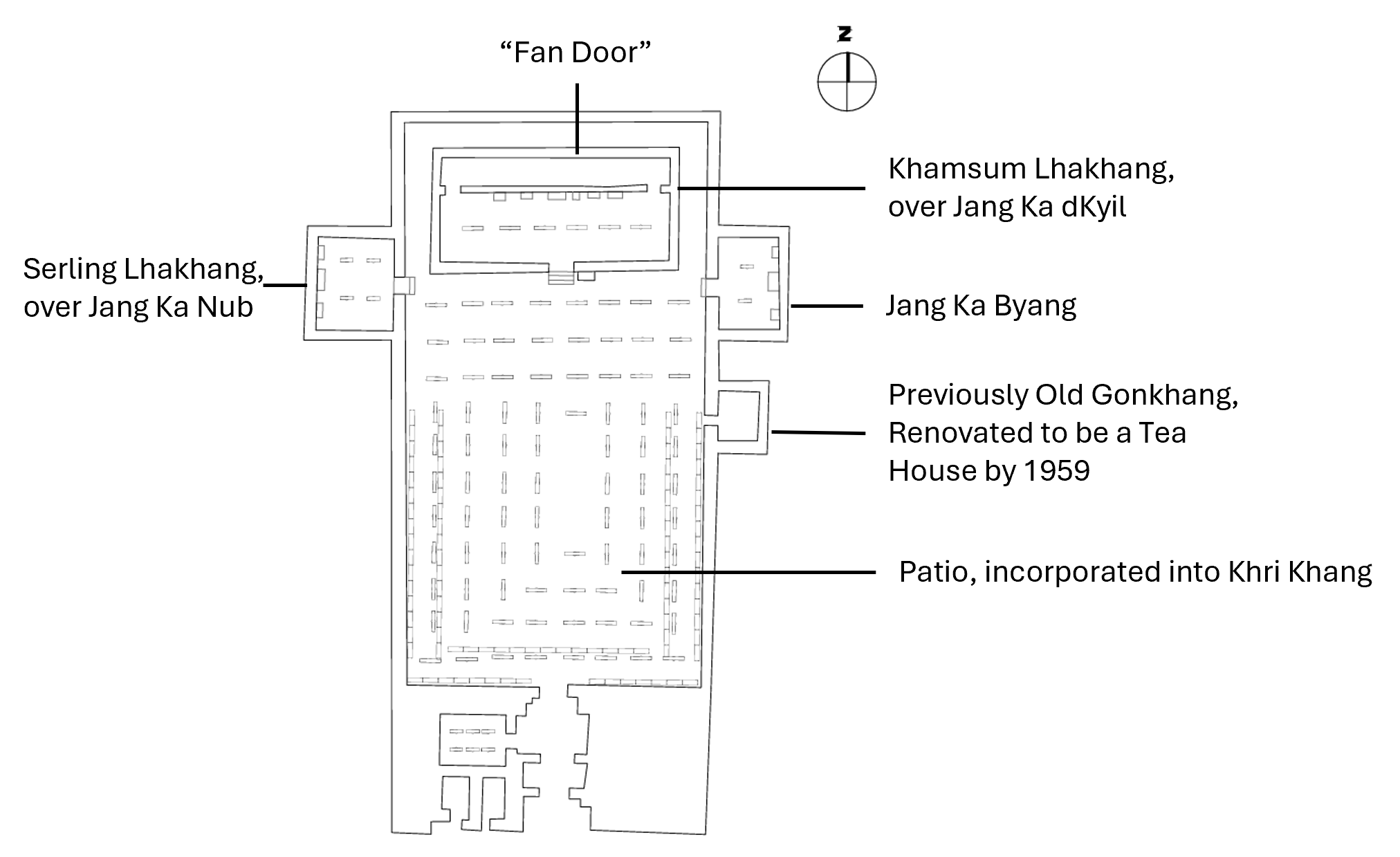

The interior of the Parkhang (printing press) was modelled from multiple sources. The hand-drawn floor plan and photographs of the interior informed the scale, dimensions, circulation of the space.
Left: Floor plan of Parkhang Chenmo (121). Su Bai. 1996. Archeological Studies on Monasteries of Tibetan Buddhism. Beijing: Cultural Relics Publishing House.
Center: Woodblocks arranged in shelves along the periphery of Parkhang’s Khri Khang. Charles Bell in Matthew Akester and Mkhyen-brtseʼi-dbang-po. 2016. Jamyang Khyentsé Wangpo’s Guide to Central Tibet, Dbus gtsang Gnas Yig. Chicago: Serindia Publications, 567.


The campus extents and exteriors were modelled from multiple sources. A Tibetan thangka painting and hand-drawn perspectives informed the color, material, heights, and building organization.
Left: Thangka painting depicting the monastery entrance toward the western side of the south enclosure wall. The Himalayan Art Resources, Item: Teacher (Lama) - unidentified, male, monastic. Ground mineral pigment on cotton. Item Number: 81872.
Center: Depiction of Nartang Monastery from 1850s map. Diana Lange, An Atlas of the Himalayas by a 19th Century Tibetan Lama: A Journey of Discovery, 260. Boston: Brill., 2020, p260.


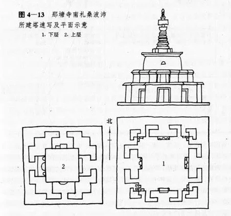
The monastery’s unique Tashigomang was modelled from photographs and hand-drawings that allowed for a precise, scaled digital reproduction of the sacred structure.
Left: Floor plan of Tashigomang’s two levels, Su Bai. 1996. Archeological Studies on Monasteries of Tibetan Buddhism. Beijing: Cultural Relics Pub. House.
Center: Floor plan and exterior elevation of Tashigomang’s two levels (Su Bai 1996, 136)


Nangchen Palace Digital Reconstruction
Nangchen Palace is yet another example of Tibetan built heritage that was destroyed during the Cultural Revolution. A reconstruction of this site allows for a closer examination of their architectural legacy and deepen an understanding of Tibet’s history.